 Gull Rock Lighthouse
Gull Rock, an islet 15 feet (4.6 m) high, is situated about 1.2 miles east of Western Head on an extensive bank containing numerous dangers.
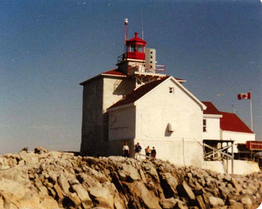
Light. - A light is shown from a white rectangular building 44 feet (13 m) high, sur- mounted by a square tower on Gull Rock. A fog signal of one blast every 30 seconds is sounded from the light structure; the horn points 130ft. A submarine power cable is laid from Gull Rock to the mainland NW. The portion of the lighthouse in front of which the family is standing was removed after automation.
Photo - © Courtesy Leona Ringer, Gull Rock Lighthouse, 1984.
Shirley Ringer and Bill Ringer, the Keeper, and their children Sheldon and Darnell, by the lighthouse
 Panorama 2008
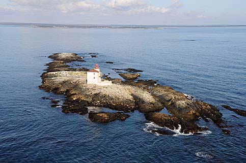
This image was taken from a Coast Guard helicopter. This must have been a difficult station for a keeper with a family, despite the fact that it is not far from the mainland.
Photo - Courtesy Department of Fisheries and Oceans
Gull Rock Lighthouse, 2008
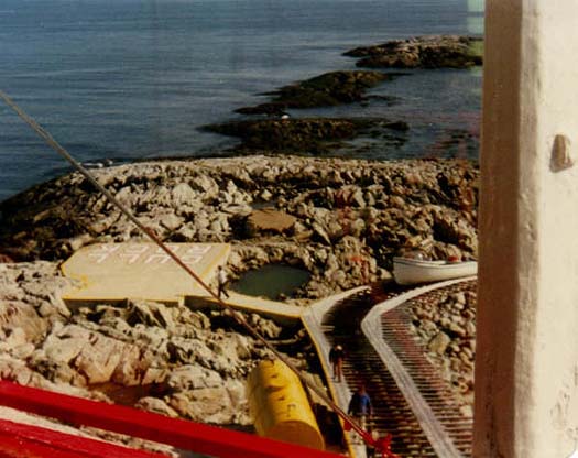 A view down from the lighthouse at Gull Rock
From left to right, you can see the helicopter pad, slip for pulling up the station boat, the oil tank and keepers carrying supplies.
ACKNOWLEDGEMENT: Leona Ringer
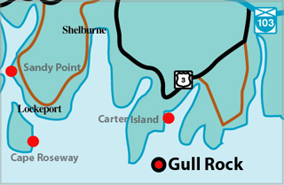
Gull Rock Lighthouse Locator Map
GULL ROCK I - Light Details
- Location: Entrance to Lockeport Harbour, 1.5 miles off
- Standing: This light is no longer standing.
- Operating: This light is no longer operating.
- Began: 1853
- Year Lit: 1853
- Structure Type: Square wood tower, concrete foundation, red lantern
- Light Characteristic: Occulting White (1922)
- Tower Height: 031ft feet high.
- Light Height: 056ft feet above water level.
History Items for This Lighthouse
- 1883 - listed as Rugged Island Harbour, fixed white, 10m
- 1918 - fog signal established
- 1922 - 4th order dioptric lens, group occulting white (30s), air diaphone
- 1930 - in operation, compressed air diaphone fog signal
GULL ROCK II - Light Details
- Location: Entrance to Lockeport Harbour, 1.5 miles off
- Standing: This light is still standing.
- Operating: This light is operational
- Automated: All operating lights in Nova Scotia are automated.
- Date Automated: Automated by 1987
- Began: c1955
- Year Lit: c. 1955
- Structure Type: Square wood and concrete dwelling, red lantern on top
- Light Characteristic: Occulting White (1990)
- Tower Height: 039ft feet high.
- Light Height: 056ft feet above water level.
History Items for This Lighthouse
- 1941 - 1960 - replaced original tower of 1853
- 1960 - 1965 - fog horn sounded from tower
- 1960 - 1965 - fog horn sounded from tower
Lightkeepers for Gull Rock Lighthouse
- W.R.R. (Roy) Murphy 1954 – 1961
- Ringer, Bill 1964 -1986
- Guptill, Jim 1974-1977
Highlights
- County: Shelburne
- Region: Yarmouth & Acadian Shore
- Body of Water: Lockeport Harbour
- Scenic Drive: Lighthouse Route
- Site Access: By Boat
- Characteristic: Occulting White (1990)
- Tower Height: 039 ft
- Height Above Water: 056 ft
- Latitude: 43~39~18.46
- Longitude: 65~05~56.062
- Off Shore: Yes
- Still Standing: Yes
- Still Operating: No